
Geometric Functions
Studio provides a set of functions for working with geometries.
| Function | Description |
|---|---|
buffer() | Creates a buffer polygon surrounding a point on the map. |
bufferFeature() | Creates a buffer polygon surrounding a GeoJSON Geometry feature. |
bufferH3() | Creates a polygon surrounding an H3 cell. |
centroid() | Returns the center point of a GeoJSON Geometry feature. |
latLngToPoint() | Creates a GeoJSON Point from latitude/longitude coordinates. |
pointLat() | Returns the latitude of a GeoJSON Point. |
pointLng() | Returns the longitude of a GeoJSON Point. |
buffer
Create buffer polygons surrounding each set of latitude/longitude coordinates.
Method
buffer(lat: number, lng: number, bufferDistance: number, distanceUnit?: string, pointsPerArc?: number): FeatureParameters
| Parameter | Type | Description |
|---|---|---|
lat | number | Required. A column containing latitude coordinates. |
lng | number | Required. A column containing longitude coordinates. |
bufferDistance | number | Required. The length of the buffer surrounding the point. |
distanceUnit | string | The distance unit to use for the buffer, either Meter/Meters, or Mile/Miles (not case-sensitive). Default: Mile |
pointsPerArc | number | The number of points to create the rounded corner of the buffered shape. A higher number of points generates a smoother buffer corner. Default: 10 |
Returns
Returns a GeoJSON feature buffer for each set of coordinates.
Example
Suppose lat and lng contain latitude and longitude coordinates, respectively.
Create a smoothed 40-meter buffer surrounding each point on the map:
buffer(lat, lng, 40, "meter", 40);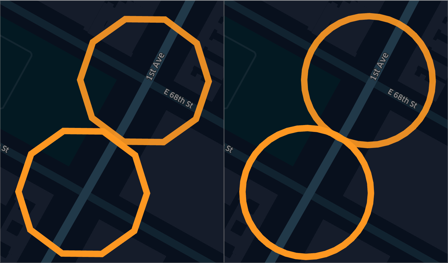
Left: pointPerArc = 10; Right: pointsPerArc = 40
bufferFeature
Create buffer polygons surrounding a set of GeoJSON features/objects, such as polygons or multi-polygons.
Method
bufferFeature(feature: Feature, bufferDistance: number, distanceUnit?: string, pointsPerArc?: number): FeatureParameters
| Parameter | Type | Description |
|---|---|---|
feature | GeoJSON feature | Required. The name of the GeoJSON feature column to surround with buffer polygons. |
bufferDistance | number | Required. The length of the buffer from the edge of each feature. |
distanceUnit | string | The distance unit to use for the buffer, either Meter/Meters, or Mile/Miles (not case-sensitive). Default: Mile |
pointsPerArc | number | The number of points to create the rounded corner of the buffered shape. A higher number of points generates a smoother buffer corner. Default: 10 |
Returns
Returns a GeoJSON feature buffer for each existing GeoJSON feature.
Example
Suppose roads is a column containing a set of GeoJSON polygons representing roads.
Create a 50-meter buffer surrounding each road on the map:
bufferFeature(roads, 50, "Meter");bufferH3
Create buffer polygons surrounding each H3 cell.
Method
bufferH3(h3: string, bufferDistance: number, distanceUnit?: string, pointsPerArc?: number): FeatureParameters
| Parameter | Type | Description |
|---|---|---|
h3 | string | Required. A column containing H3 cell strings to surround with buffer polygons. |
bufferDistance | number | Required. The length of the buffer from the edge of each cell. |
distanceUnit | string | The distance unit to use for the buffer, either Meter/Meters, or Mile/Miles (not case-sensitive). Default: Mile |
pointsPerArc | number | The number of points to create the rounded corner of the buffered shape. A higher number of points generates a smoother buffer corner. Default: 10 |
Returns
Returns a GeoJSON feature buffer for each H3 cell.
Example
Suppose h3 is a column containing H3 indexes.
Create a 2-mile buffer surrounding each H3 cell in h3:
bufferh3(h3, 2);centroid
Get the centroid of a GeoJSON Geometry object. The geometry type could be Point/MultiPoint, LineString/MultiLineString, or Polygon/MultiPolygon. A geometry's geometric center of mass is computed and returned.
Method
centroid(geo: Feature): Feature<Point>Parameters
| Parameter | Type | Description |
|---|---|---|
geo | GeoJSON Geometry feature/object or a WKT string. | Required. The column containing the polygons to derive centroid from. |
Returns
Returns a GeoJSON Point feature for each polygon provided.
Example
Suppose there is a _geojson column in the dataset table.
Find the centroid for each GeoJSON Geometry feature/object in _geojson:
centroid(_geojson);latLngToPoint
Creates a GeoJSON Point feature for each set of coordinates.
Method
latLngToPoint(lat: number, lng: number): Feature<Point>Parameters
| Parameter | Type | Description |
|---|---|---|
lat | number | Required. A column containing latitude coordinates. |
lng | number | Required. A column containing longitude coordinates. |
Returns
Returns a GeoJSON Point feature for each set of coordinates.
Example
Suppose lat and lng contain latitude and longitude coordinates, respectively.
Create a GeoJSON Point feature for a set of coordinates:
latLngToPoint(lat, lng);pointLat
Get the latitude value of a GeoJSON Point feature.
Method
pointLat(pt: Feature<Point>): numberParameters
| Parameter | Type | Description |
|---|---|---|
pt | A GeoJSON Point feature/object | Required. A column containing GeoJSON Points to derive latitude from. |
Returns
Returns a numeric latitude value for each Point feature.
Example
Suppose there is a _geojson column in the dataset table.
Retrieve the latitude values for each GeoJSON Point:
pointLat(_geojson);pointLng
Get the longitude value of a GeoJSON Point feature.
Method
pointLng(pt: Feature<Point>): numberParameters
| Parameter | Type | Description |
|---|---|---|
pt | A GeoJSON Point feature/object | Required. A column containing GeoJSON Points to derive longitude from. |
Returns
Returns a numeric longitude value for each Point feature.
Example
Suppose there is a _geojson column in the dataset table.
Retrieve the longitude values for each GeoJSON Point:
pointLng(_geojson);Note:
pointLat()andpointLng()can be used to create new latitude and longitude columns for a Point layer.
Updated 5 months ago